Uncategorized
The Treasure Below
Although we have known about vast deposits of polymetallic nodules on the sea floor for nearly 150 years, their exploitation has only recently advanced…

The story starts in 1873, when HMS Challenger, while conducting a survey of the sea floor, dredged up “several peculiar black oval bodies which were composed of almost pure manganese oxide”. We now know that these nodules also contain significant amounts of nickel, cobalt, copper and rare earth elements.

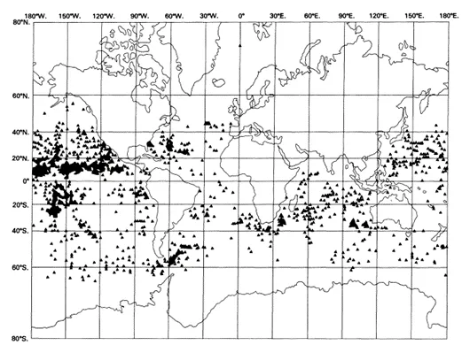
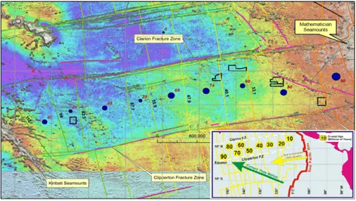
Subsequent exploration has shown that polymetallic nodules cover vast tracts of the deep ocean floor, as the map (Figure 2) from the Scripps Institution of Oceanography shows. Note the particularly dense occurrence of nodules on the left of the map, in the tropical waters of the north-east Pacific Ocean. This area is known as the Clarion Clipperton Zone or CCZ. The CCZ is a vast tract of sea floor between the Hawaiian Islands and the west coast of Mexico, defined by two major WSW-trending fractures: the Clipperton and Clarion fracture zones. The depth of the ocean in the CCZ ranges from about 4,200 m to 5,000 m.
Largest undeveloped source of battery and rare earth metals
Polymetallic nodules are believed to have precipitated from seawater, growing slowly over a few million years, soaking up metals from the seawater and the seafloor sediments. The CCZ appears to be something of a sweet spot in terms of the supply of metals, conditions for the precipitation of the metals, and conditions for their preservation.
The area covered by nodule fields within the CCZ is huge, extending over millions of square kilometres. The International Seabed Authority (ISA) has estimated that the CCZ contains some 30 billion tonnes of nodules containing 70 million tonnes of cobalt (about 500 years of supply), 400 million tonnes of nickel (about 200 years of supply) and 340 million tonnes of copper. This is a truly remarkable accumulation of metals. In some areas, polymetallic nodules also carry elevated grades of rare earth elements (REEs) that are essential for many modern technologies.
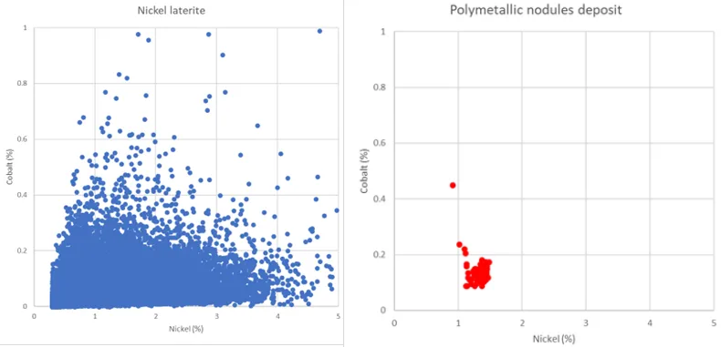
Another remarkable characteristic of the nodule deposits in the CCZ is the low variation in metal grades. Figure 4, on the left, shows a plot of nickel and cobalt grades from a typical nickel laterite deposit. The plot on the right is a similarly scaled plot of nickel and cobalt grades from an area of approximately 25,000 square kilometres in the CCZ. The very low variance of the grades in the CCZ is clear. Importantly, the very low variance means that estimation of grade is very low risk.
Exploring the ocean floor
For deep-sea mineral deposits, all data must be gathered remotely. There’s no opportunity for geologists to kick the rocks or compile detailed maps of the rock types, geological structures, mineralisation styles and their relationships. And the cost of off-shore drilling and sampling is much higher than on land. These cost pressures favour the use of remotely-sensed data that are not commonly used for the estimation of terrestrial mineral deposits. Specifically, the most commonly used remote exploration methods for deep-sea nodules are:
- Multibeam echo sounder
- Free-fall grab sampling
- Box core sampling
- Autonomous underwater vehicle (AUV) photogrammetry
Multibeam echo sounder
The multibeam echo sounder is used for mapping the bathymetry—that is, the topography of the sea floor.
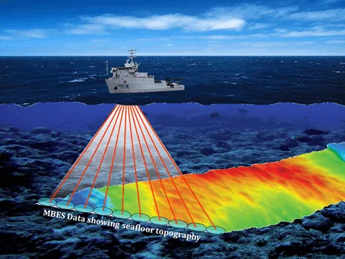
Multibeam systems are also capable of recording acoustic backscatter data, which can be useful for identifying areas of polymetallic nodule coverage or zones devoid of nodules e.g., seamounts or lava flows.
Free-fall grab sampling
Free-fall grab samplers are used to sample and measure the abundance of nodules on the sea floor. The weight of nodules collected, divided by the area from which they were collected, is the abundance of the nodules in kilograms per square metre.
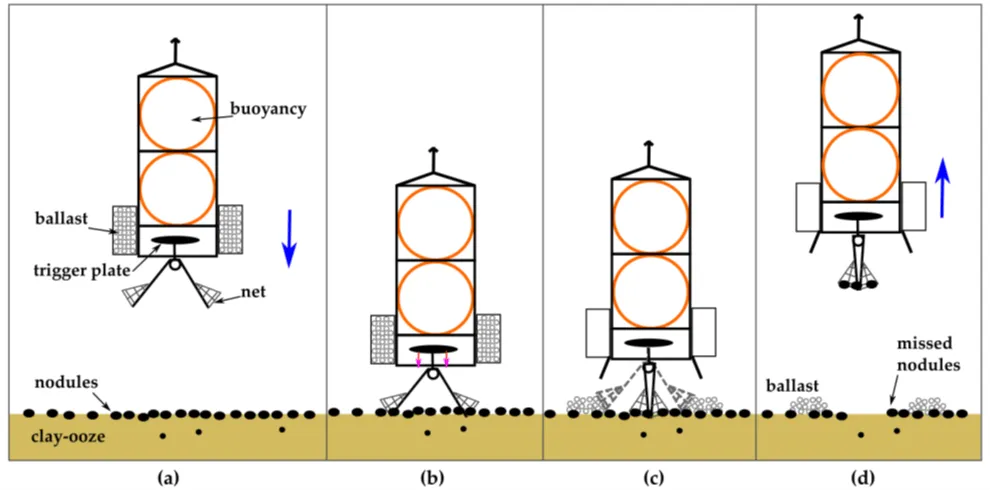
In free-fall grab sampling, illustrated in Figure 6, the sampler is released from a ship and descends slowly to the sea floor under its own weight and the weight of the ballast—hence the term free-fall. When it lands on the sea floor, spring-loaded net bags close under the sampler, scooping up nodules and sediment. The ballast containers are then opened, dropping the ballast on the sea floor. The sampler now has positive buoyancy and slowly ascends to the sea surface. It has a light and radio beacon by which it can be located and retrieved.
The advantage of free fall grab samplers is that they can be deployed and retrieved independently, without the need for winching, so several samplers can be efficiently deployed without delays. The disadvantage with free fall samplers is that smaller nodules may be lost, and the largest nodules may be too big to be caught in the net bags. So, recovery of the nodules may only be partial.
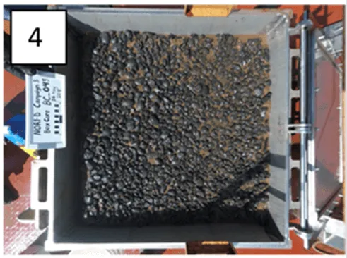
Box core sampling
The box core sampler is currently the sampler of choice because of the high quality of the samples it produces. Like free-fall grab samplers, box core samplers measure the abundance of nodules on the sea floor. Figure 7 shows the top view of the nodules inside the box core. This illustrates one of the main advantages of the box core: samples are relatively undisturbed, allowing very accurate measurement of nodule abundance and other geological and ecological properties at the sample site.
Autonomous underwater vehicles (AUVs)
AUVs are also widely used. They are operated a few metres above the sea floor to collect detailed, quantitative photographs of the nodules and small-scale topographic features. Box core sampling is laborious but photographic methods can be used to collect a large volume of data at a fraction of the cost over a large area, in a relatively short period of time.
A predictive relationship can sometimes be established through measurement of each nodule’s long axis and its weight. The graph in Figure 8 shows nodule weight plotted against nodule long-axis length. By measuring the long-axis digitally and using the calibrated relationship, the abundance of nodules within a calibrated area of sea floor can be estimated. The process is known as long-axis estimation (LAE).
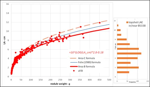
A key limitation of photo-based abundance estimation is that, in some areas, sediment cover may mask the nodules, which prevents an accurate estimate. Nonetheless, where this is not a problem, LAE is a valuable, low cost, addition to box core data.
Estimation of polymetallic nodule resources
Mineral resource estimation of polymetallic nodule deposits is a relatively simple, two-dimensional task. The estimation process involves four basic steps, which will be familiar to every geologist:
- Identify the limits of the mineralized deposit.
- Characterize the density of the mineralization. For polymetallic nodule deposits, nodule abundance fulfils this requirement.
- Characterize the grades of the deposit.
- Estimate the spatial distribution of grades and abundance within the deposit.
The deep-sea floor is not flat, and definition of the topography is important because there are seamounts and volcanic ridges on which nodules may not have been preserved. Sea floor topography will also likely constrain commercial nodule production. For example, recovery of nodules from the steeper slopes may not be practical.
Having mapped the extent of the areas interpreted to have nodule coverage, the box core samples, free-fall grab samples, and LAE data are used to estimate nodule abundance and mineral resource tonnages and grades. Simple, spatial averaging techniques, such as ordinary kriging, are sufficient to model the spatial distribution of abundance and grades.
Deep sea exploration methods are unfamiliar to many traditional mining stakeholders and unfamiliarity may easily lead to misunderstanding and lack of confidence in the mineral resource estimates. So, thorough, good quality reporting of mineral resource estimates for polymetallic nodules takes on an extra significance. All relevant information must be presented in a clear and balanced manner to inform stakeholders such as exploration companies, their shareholders, regulators, and wider communities.
Mining 5 kilometres down
There has been, as yet, no commercial production of deep-sea polymetallic nodules, but there are several private and government-sponsored research organisations actively investigating production scenarios.
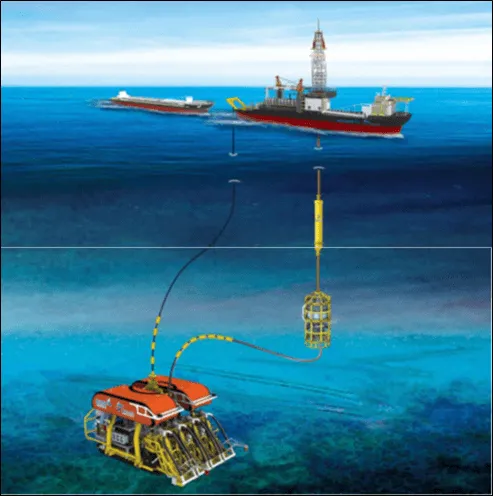
The term “mining” is something of a misnomer in terms of production of polymetallic nodules. The nodules are sitting on the sea floor: no waste rock stripping, no drilling, no blasting. A conceptual mining scenario is illustrated in Figure 9. A collection machine, probably self-propelled, picks up the nodules from the sea floor with minimal disturbance. The nodules are fed into a pumping system, which lifts them to a production support vessel. The production support vessel transfers the nodules to bulk carriers, which in turn transport the nodules to a land-based site for processing.
The technical risks are moderately high at the present time because no full-scale systems have yet been built and operated. The oil and gas industry already operates at depths of several thousand metres, so developing systems to operate at great depths is not an insurmountable engineering challenge. And several small-scale trials of prototype collection machines and pumping systems or skip systems have been successfully completed.
Economic recovery of deep-sea mineral deposits will entail the use of technologies that are new, or adaptations of componentry and systems developed for terrestrial environments, shallower waters, or other industries. Cost estimates for terrestrial mines can be benchmarked against numerous other deposits with comparable geology and operating environments. There are currently no commercial-scale deep-sea mines that can be used as benchmarks, so estimates must be constructed methodically from first principles and draw on practical experience from marine engineering in other well-established industries.
The majority of terrestrial mines operate within significant constraints imposed by the geometry of the ore and the waste rock which typically surrounds and overlies the ore. This places practical and economic limitations on the sequence in which the ore can be extracted and means that there is commonly a significant volume of waste that must be removed and placed into long-term storage. In contrast, seafloor mining systems for polymetallic nodules will have high mobility and will not have any waste material to move or store. It is therefore expected that seafloor operations will be highly adaptable and able to respond rapidly to changes in the operating environment.
More work is definitely required to bring nodules projects to fruition, but progress is now rapid and the outlook is exciting.
The ESG argument
The international seabed area is defined as the seabed and subsoil beyond the limits of national jurisdiction. The international authority responsible for overseeing and managing the development of this area is the International Seabed Authority (ISA). Made up of 167 Member States, and the European Union, the ISA is mandated under the UN Convention on the Law of the Sea to organize, regulate and control all mineral-related activities in the international seabed area for the benefit of mankind as a whole. In so doing, ISA has the duty to ensure the effective protection of the marine environment from harmful effects that may arise from deep-seabed related activities.
The principles that exploitation of the mineral resources of the deep seabed should be carried out for the benefit of all humanity and that the proceeds from such exploitation should be shared on the basis of equity were recognized from the beginning of discussions in the United Nations. All Member States have the opportunity to sponsor applications for exploration and exploitation licences through their state-owned entities or partnerships with commercial organizations. This provides even small nations, such as Nauru, Tonga, and Singapore the opportunity to benefit from mining of the deep seafloor.
The ISA has published regulations governing the prospecting and exploration of polymetallic nodules, including guidelines for the establishment of baseline environmental data. A legal framework to regulate the exploitation of polymetallic nodules in the international seabed area is also being developed. The aim of the ISA regulations is to balance economic needs with rigorous environmental protection. The current ESG requirements focus on the exploration activities and include:
- Which seabed exploration activities are likely to have environmental impacts and to what degree?
- What baselines should be used to measure the state of the environment prior to exploration activities and how should subsequent changes be monitored?
- What research should be conducted into natural and anthropogenic (human-induced) processes at work?
A significant number of studies of the CCZ have been completed over the last 40 years and are on-going, including ocean currents, phytoplankton and benthic fauna, biodiversity, nutrient chemistry and suspended matter, sediment dispersion, and ecosystem function and recovery from past dredge tracks and impact experiments. The studies indicate that exploration and mining activities can be conducted in a manner that minimises both the disturbance in areas outside of the mining areas and long-term impacts on the marine environment.
Implementation of appropriate environmental management systems and management plans will be necessary to provide the overall framework for environmental management and monitoring. It is expected that the mobility of the seafloor production systems will be advantageous when using adaptive management systems to control environmental impacts.
There are likely to be few negative social impacts in many of the prospective deepsea areas because they are far from human habitation or fishing areas. Mining of deepsea nodules is not expected to require tailings ponds or other large-scale waste storage, either offshore or onshore, and the concentration of harmful elements in the nodules is very low.
The transition to green energy and the associated electrification of the world will require a vast quantity of copper, cobalt, and nickel. This demand cannot be met from terrestrial mines without further competition for land and water use and impact on communities and the environment. The potential for mining of deepsea nodules presents an alternative that will have, in many respects, significantly lower social and environmental impact. These are the choices that must be considered and made by the world in the very near future.
About AMC Consultants
Through our work on several deep-sea projects in recent years, AMC has developed a thorough understanding of the technologies, opportunities and risks involved. If you want to learn more about this fascinating topic, AMC Principal Geologists Ian Lipton and Nick Szebor will be happy to guide you along the path.
Curious to find out more bout how AMC can help you with your deep sea mining project?
The post The Treasure Below appeared first on Mining Technology.